Trip to Hidden Paradise – Hunza Valley


To recap, I mentioned in my previous Blog Trip to Hidden Paradise via Naran that we divided our trip into two short trips. First was to travel from Lahore, Punjab to Naran, KPK. Second one was from Naran, KPK towards Hunza Valley, GB.

Trip to Hunza Valley from BabuSar Top

This is the continuation of my Trip to Hunza Valley from BabuSar Top onwards. For about 45 Minutes, you’ll finally reach to a level where steep descend will be low enough. But you will keep going on the Winding road further.

Entering Gilgit Baltistan

One thing you will notice as you Enter in Gilgit Baltistan area after Khyber Pakhtunkhwa, the color of mountains change.

After driving through for an hour and half on N15, we joined Karakoram Highway N35 along with Indus River.

Right at that point, Chilas is at your left side. And on your right, it’s your further trip down towards Hunza Valley.

Nanga Parbat Peak

While we were on N35, we witnessed Marvellous and Beautiful Peak Nanga Parbat. It is at 8126 meters high, and 8th highest peak in the world.

On N35 after about 1 hour and 15 minutes, you will reach to a point called Raikot Bridge. It is Gateway point to Fairy Meadows and Nanga Parbat over Indus River. You will notice lot of Jeeps and a Resort which I will not recommend you to stay. At even for lunch or dinner, due to their worst customer service and hotel services.

Indus Gilgit Confluence

After travelling through further 35 to 45 minutes, we reached at The most Historic point at Jaglot. It is called Indus-Gilgit Confluence. It’s where The three Mightiest Mountain Ranges of the Himalaya, Karakoram, and Hindu Kush come together in Pakistan at the Confluence of the Two Rivers, namely Indus River and the Gilgit River

After further 45 minutes or 50 Kms worth of travel , we reached at Gilgit. It is Capital of Gilgit Baltistan Province of Pakistan, but we didn’t stay there. Gilgit was on our right side and we kept going further straight on N35.

Rakaposhi Peak

After 1 hour and 30 minutes, we reached at Rakaposhi View point. From this point, we could clearly see Mesmerising Rakaposhi Peak. It is 7,788 meters high which makes it 27th highest peak in the world. Its known as Mother of Mist as well.

Hunza Valley

Further onward, there’s only 1 hour left to our Hotel destination Hunza View Hotel (HVH). It is situated in Karimabad. It’s one of the old Hunza Valley Hotels, with a history. As soon as you enter the hotel, you’ll soon realize that you have entered at a Tourist spot. It’s a 3-star hotel at a very prime location. From it you could view Peak of mountains from your Balcony.

We were so tired that we all slept after having early dinner, and woke up early in the morning. We were greeted by the beautiful Hunza Valley mountains.

Altit Fort and Baltit Fort

We had a plan to visit Altit Fort and Baltit Fort, hence we reached to Baltit Fort first. Altit Fort is about 1100 years old whereas Baltit Fort is about 900 years old Fort. In earlier days the area was built between different states with different rules and they had many wars among them too.

At Baltit Fort, we were shown multiple sections of it. There were two chambers, one on roof top with all of kings advisors used to sit for meetings. The other place is where queen used to sit and resolve women issues there.

Hunza has Literacy rate of more than 77% and famous for Apricots and Cherries.

After visiting Baltit Fort we had delicious Cherries from Morning Glory Restaurant which is famous for Apricot and Cherry Juices.

Tip: One thing you must remember that these Forts are built on mountains, so when you go up on Baltit Fort, it’s a steep hight and lots of stairs. If you’re not physically strong, then you may not be able to reach Baltit Fort. There are few Jeeps available for Older, sick or children to take them up there.

Duikar Mountain Peak

Our next destination was to stay at Eagle nest Hotel which is on Duikar mountain peak. It is about 25 min to 35 minutes drive upwards from Karimabad with 8 to 10 very steep turns.

Once you get there, its a whole new world you can see from the peak with mesmerising and splendid Valley views.

Best thing about Eagle Nest is it’s View. we could see Lady finger peak on our one side, Golden peak on the opposite side, Rakaposhi Peak at the north and Ultar peak at the south.

Golden Peak

There are couple of shops around eagle nest from which you can buy local made goods. We witnessed during Sunrise Golden Peak with Gold colour on it.

After our stay at Eagle Nest Hotel, our next destination was Atabad Lake.

Karakoram Highway Tunnel

We traveled through Karimabad, and crossed Karakoram Highway Tunnels going through multiple mountains, which were built after Atabad lake blocked the Karakoram Highway Road.

Karakoram Highway tunnels are a symbol of Pakistan China Friendship which helped not only transportation but many Locals who had to cross through Boats. Now you travel the entire long lake distance through Karakoram Highway Tunnels which are about 5 of them spread across 24 km (15 mi) from multiple mountains.

Tip: Please note that Google Maps will not show you Tunnels, so don’t worry about it and follow signs towards Atabad and Passu.

Atabad Lake

We reached at Beautiful Atabad lake after travelling from Karimabad for about 30 to 45 minutes. It comes at your left side of it and it made me stop my car to take a picture, as I have never seen any lake like this before due to it’s natural parrot blueish green colour of it.

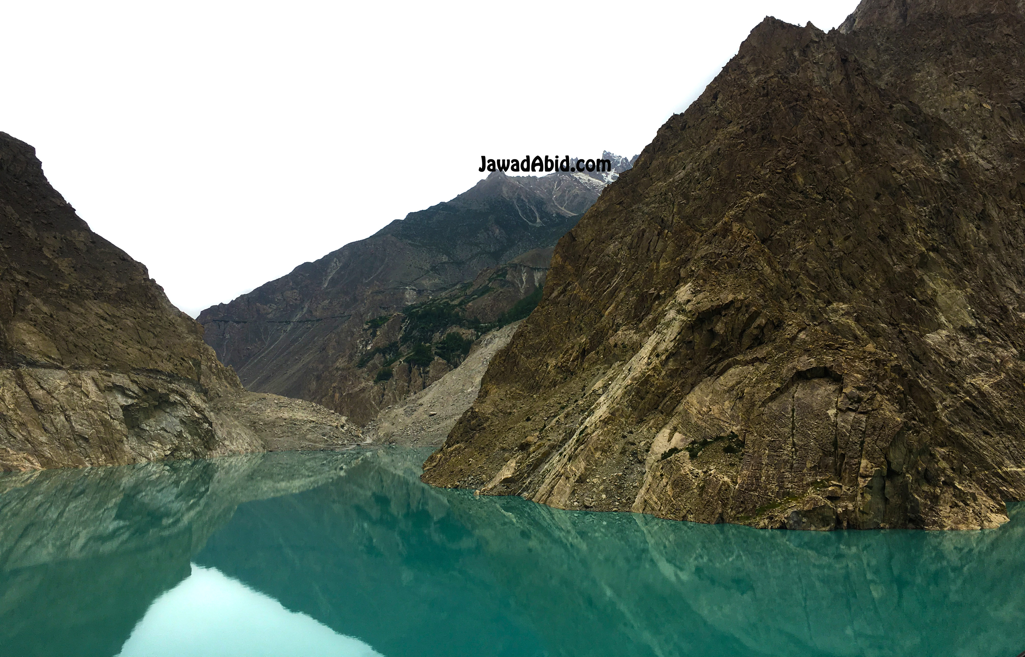
Atabad lake is long lake which got formed due to major land sliding on Hunza river. Once you’re out of tunnel, there’s a spot at Shishkat for water sports which is on Atabad lake, that includes boating, Fishing and Jet skies.

Passu Cones

On our way through towards Hunza Valley, we could see Beautiful Passu Cones.

On our way, we saw Hussaini bridge, which is a very old hanging bridge, connects  made on top of Hunza river which connects Zarabad Hamlet to Hussaini Village. We crossed by it and saw mesmerising Passu Peaks right in front of us.

Borith Lake

There’s a road on Left, if coming towards Passu from Atabad which leads towards Borith Lake.

Tip: The road is very thin with steep turns of approximately 10 minutes. If you’re not an expert in driving on dangerous tracks, then you can call Borith Lake Resort to have their Driver, drive your car or in their Jeep up towards the Lake.

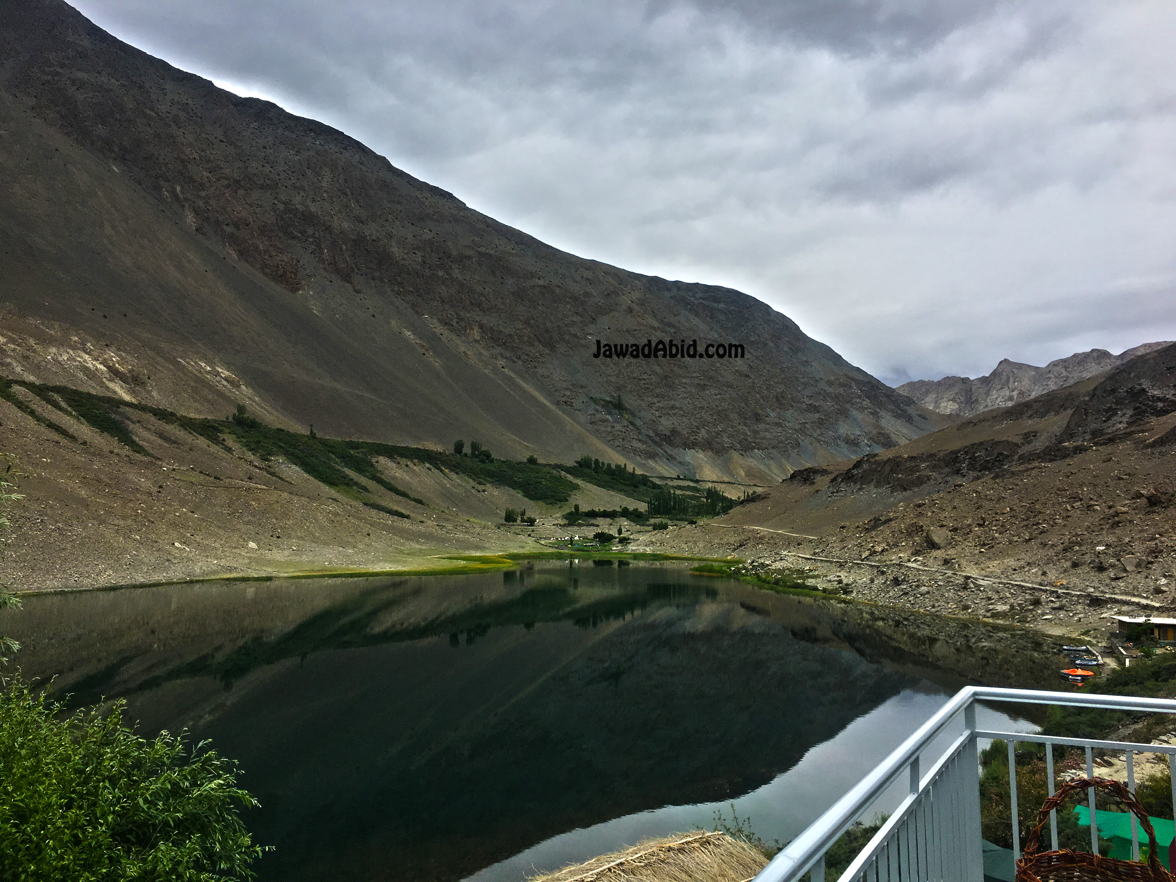
Once we reached at Borith Lake Resort, it was A Heaven in Heavens. We stayed at Borith lake hotel and resort for further three nights. Our rooms front view was a lake view surrounded by mighty and beautiful Ultar Peak and Shispare Peak.

In our surroundings we could see Passu cons on our right, and slightly on its further right there’s Gulmit peak with Gulmit Glacier and Ghulkin glaciers.

Borith Lake resort is very beautiful, clean, with fresh water. The colour of lake is so pure, that after enjoying Atabad lake, it was another master piece. Resort management was very friendly and their quality of food was amazing.

Khunjrab Pass

Khunjrab pass from this lake is around 110 km which can be covered in 3 to 4 hours approximately to it one way.

Khunjerab Pass is a high mountain pass in the Karakoram Mountains, in a strategic position on the northern border of Pakistan.
It is the highest-paved international border crossing in the world and the highest point on the Karakoram Highway.

Gilgit Baltistan Wild life

Locals told us that they do see Snow leopards at the other side of Borith lake rarely, and as Wild Life Rules became stronger there, they now see increase in snow leopards. Along with it local community also promotes preservation of Wild life there. They have seen last year about 250 to 300 IBEX (Mountains Goats) which is an increased number from past couple of years.

We stayed in Hunza for a week which ended too soon for us. I personally never wanted to leave such beautiful paradise and I’d love to come back here. The next morning we left at 5 am from Borith Lake, and continued our journey to Naran the same way we came from Lahore.

Tip: It is recommended to leave BabuSar Peak maximum by 2 pm as there’s 4 hours distance from BabuSar Peak to Naran KPK. 

Five Rivers with different colors

We have seen 5 different colors of water in Rivers and Lakes throughout the Trip from Grey, Brown, Blue, Sky blue and Green.

If you liked my blog then you may like blog to Naran Valley as well.

Did you find some great Tips and useful information in this Blog? Please do write us If  you have visited Hunza Valley or Kaghan Naran Valley before, if so how was your Journey and what was your favourite Spot?

P.S. If you enjoyed this post, I’d be very grateful if you’d help it spread by using Share buttons on your preferred social platforms. Thank you!

About Author:

Jawad Abid is multi-talented Business, Technology and Customer Service Professional with two decades of Experience with Large Telecoms, Banks & Outsource Service Providers, Startups and Fortune 500 companies in multiple Roles. He’s passionate about Gaining Knowledge on Technologies, How Technologies enable Businesses & Improve Lives, and Sharing Knowledge in the attempt of giving back to Community.

Check out his Blogs at Blogs Section

This is originally posted on Jawadabid.com. #Passion #Productivity #CareerAdvice #Successful #Motivation

You can follow me on:
LinkedIn  at Jawad Abid
Twitter at Jawad Abid

Trip to Hidden Paradise – Hunza Valley via Naran

Pakistan is a naturally rich Country in South Asia, with all types of seasons available, with many Beautiful and Stunning Paradises. This time around I managed to visit this hidden Paradise at Hunza Valley, in Gilgit Baltistan. It’s a Province of Pakistan and along the way I explored mesmerising paradises. Those include Kaghan Valley, Naran Valley, Saiful Malouk Lake, Lulusar Lake, BabuSar Top, Hunza Valley, Gilgit, Passu Cones, Borith Lake, Nagar Valley, Karimabad and Atabad Lake.

We divided our long journey trip into two trips due to long distance from Lahore to Hunza. It is about 943 km or 585 miles and straight 18 hours travel time by road.

First trip was to get to Naran and stay there for two nights. Second trip was to move on towards Hunza Valley from there and return.

I did some planning effort before going to trip which is very essential. However many people will claim to chill and not worry about it. But it’s important to Plan and be prepared for any unforeseen issues. This is to ensure you gain maximum out of this lovely time, especially if you’re traveling with families.

My Travel checklist:

+ Validated all the forecasts from online weather forecast of all destinations.
+ Kept warmer clothes with us due to weather forecast.
+ Checked nearby hotels and their locations to shortlist them.
+ Reserved our nights already at our hotels.
+ Made a list of items, I packed with me to know what I’m bringing and what I missed.
+ Got my car tyres checked which I had to upgrade, so I did.
+ Got done regular maintenance on my car to ensure there aren’t anything that left unchecked.
+ Bought some snacks and drinks already locally with some preserved food items.
+ Brought extra shopping bags with us so I could put trash in them.

Please note that wherever you go, you must keep your trash bags with you. Therefore you could throw trash in them, instead of ruining the beauty of that place. We have seen trash/used wrappers/bags at the banks of lakes, resorts and Mountain treks. They are heart breaking and frustrating, at how people have misused the God gifted paradise.

Our Trip started on the early morning at 01:00 am on 22nd June, 2018. We had clear skies from Lahore, Punjab by road.

Kalar Kahar / Salt Range

We started our journey through lush green M2 Motorway, all the way through beautiful Kalar Kahar and Salt Range mountains. I must share that Khewra Salt mines are second largest Salt Reservoirs in the whole world.

After crossing Kalar Kahar, Islamabad was just 2 hours away. We took our break at M2 – Service Area at Kalar Kahar.

After that, we kept driving straight towards Peshawar via M2 Motorway to M1 Motorway.

E35 Expressway / M15 Motorway

Around Hassan Abdal area, after crossing Burhan interchange, we took left Exit towards E35 Hazara expressway. E35 Expressway is also known as M15 Motorway, or CPEC Motorway. It is 180 km controlled-access between Punjab & KPK.

At Shah Maqsood Interchange, we took turn towards N-35 National Highway at around 7 am in the morning.

This highway led us towards beautiful Abbottabad and Mansehra cities. It’s important to mention that N-35 goes through the Abbottabad city. Therefore, you should try to go through the Main city before 8 am in the morning. Peak hours in city are from 10am to 4pm or 4pm to 7pm.

There’s another and more recommended route recently added on Express Highaway. It takes you straight till Mansehra instead of going through Abbottabad city.

Before entering Mansehra city, there’s Zeeb Town from where you’ll take right turn towards Balakot on N15. After that, there’s another alternate route as well which passes through Mansehra City. But we took this N15 Highway route to avoid City traffic.

When you cross initial patch of the N15 route, there’d be slightly rough patch in start for about 5 minutes. After that, the road is in Good condition towards Balakot.

Mansehra City

On the way to Balakot, you’ll witness Mansehra city on your left spread out all across and mountain on your right. It is the capital of Mansehra District in KPK Province.

Mansehra City by JawadAbid.com

After driving round and round of about 30 minutes’ drive, you’ll reach to Balakot. Please remember you can get motion sickness in those rounds of Mansehra.

Balakot

Once you reach Balakot, you will see the first glimpse of Beautiful Kunhar river. You will absolutely want to stop your car for that breathtaking view with mountains at the back.

Balakot view by JawadAbid.com

We stopped our car for Quick breakfast at the hotel, near bank of Kunhar river, at around 8:15 am. There are several resorts and restaurants you can pick from based on your preferences. Similarly, they will serve you breakfast at the bank of Kunhar River which makes the breakfast experience even better.

Kunhar River by JawadAbid.com

From there onwards, we crossed Balakot which is located at the bank of Kunhar River.

Kaghan and Naran Valley

After crossing Balakot, you’ll reach to another paradise called Kaghan Valley, which is 155 kilometers long valley. It is at an elevation of 2,134 feet to its highest point to the Babusar Pass, at 13,690 feet.
It was perfect timings in the morning with sun behind green mountains and Kunhar River passing by the valley.

After that, we traveled for an hour or so, and reached Kiwai. From this point, you can take tour towards Beautiful Shogran and Siri Payee. There would be Lot of Special Jeeps available to take you for the ride.

We continued to move as our base camp was in Naran, as we moved forward. On the way, we reached Kaghan town. We took the couple of lush green beautiful mountain pictures with a quick stop for ten minutes.

Kaghan Valley by JawadAbid.com

After that, we moved further for an hour, we reached Naran town around 11 am. We were not surprised at how Naran town was built past few years. It has been commercialized a lot, with lots of Hotels and Restaurants on the sideways. We crossed the congested strip of Hotels at Naran and took right on Saiful Malouk Road towards our Hotel.

Saif ul Malook Lake

The next morning, we took a Jeep ride towards Most beautiful and Amazing Saiful Malouk lake.

Saiful Malouk Lake is located at an elevation of 3,224 m (10,578 feet) above sea level, with a last known depth of 50 ft.

You could see highest peak in the area at the back of this lake called Malika Parbat which is 5,290 metres (17,356 ft) high.

My view of Saiful Malouk by JawadAbid.com

After coming back from Saiful Malouk Lake, we took a quick rest and went towards the Rafting point at Kunhar River, located on Karakoram Highway N15 towards Lulusar Lake.

Saif ul Malouk and Malka Parbat View at JawadAbid.com

Kunhar River Rafting

We went back from Saiful Malouk Road towards Naran (Town) and took right towards Babusar Top. The spot for Rafting was only 15-25 minutes’ drive on N15 Highway.

Tip: Before you go for Rafting, make sure you have dry shorts/bathing suit, sandals with straps, and wet suit boots. During Rafting they will get your signature for disclaimer. Give you all precautionary instructions and provide life jackets too.

We loved every bit of Rafting adventure with our cousins. We wanted to do it again, but it was already sunset so we had to mark that for next time.

After that, we had to check out Lulusar Lake and Babusar Top, also known as Babusar Pass. It is located at elevation of 4,173 metres or 13,691 feet. They both are on same N15 Highway going towards BabuSar Pass.

LuluSar Lake

The next morning, we left at 6:00 am sharp towards BabuSar Pass. We planned to reach to Hunza Valley before sunset. We stopped by at Lulusar Lake and Babusar Top on the way, hence started early to have enough time.

Tip: Please note that there are lot of Open Fuel / Gas shops, which are selling at their own rates. In case you get stuck, you still have a chance to buy extra gas or fuel from them. I don’t recommend to buy from them.

As you go on N15 highway towards Babusar Pass, you’ll witness lot of breathtaking sceneries with Kunhar river flowing with you. In addition, you’ll also see herds of mountain goats passing by too.

After an hour and 30 minutes on N15 highway, we reached to magnificent Lulusar Lake. In addition, it is located at 3,410 m (11,190 ft.), is the primary headwaters off the Kunhar River. It flows southwest through the entire length of Kaghan Valley passing Jalkhand, Naran, Kaghan, Jared, Paras and Balakot until its confluence with the Jhelum River. Lulusar lake is located about 48 kilometres (30 mi) away from Naran. It is accessible by any kind of vehicle.

Lulusar Lake by JawadAbid.coml,

We could see reflection of Sky and mountains on the mesmerizing lake. We took a couple of pictures there while we stopped there for fifteen to twenty minutes.

BabuSar Top / BabuSar Pass

From Lulusar Lake, it took us about 45 minutes to 1 hour, to reach at BabuSar Top. It got colder as we passed through BabuSar Top. However, if temperature decreases enough, you could see snow fall there too quite often. As soon as we reached to BabuSar Top, we could see all the peaks top from there.

We stopped at BabuSar Top for few pictures and some snacks. There’re some tuck shops and temporary restaurants to entertain you with food. For instance, you could order tea and pakoras there.

Babusar Top is located at an elevation of 4,173 meters or 13691 feet along the Kaghan Valley. It connects Khyber Pakhtunkhwa with Gilgit Baltistan province of Pakistan. In addition, it’s the highest peak that is accessible through cars and jeeps.

This range of mountains flanks the right bank of the Kunhar, contains a peak Malika Parbat. It is at over 17,000 feet, the highest in the district.

From this point onwards, Chillas is 40 Km and Gilgit is 180 Km away. Khunjrab is 384 km, Kashghar is 802 Km, Tashkent is 1866 Km and Beijing is 5252 Km.

We left immediately as we had to reach to Hunza Valley before sunset and had a planned lunch at Chilas.

Tip: If you run into flat tyre, there’s a small tyre shop. It is next to BabuSar Top towards Chilas 5-10 minutes ahead.
There’s a very steep drive from Babusar Top towards Chilas
. Therefore, you must drive your car slow in lower gears. You must Take continuous breaks after every 15 to 20 minutes to cool down breaks and tyres.

If you enjoyed this blog, don’t hesitate to share through Share buttons. on your preferred Social Media platforms. Thank you!

Please read through my next Blog for Later trip from BabuSar Top to Hunza Valley, Gilgit Baltistan.

About Author:

Jawad Abid is multi-talented Business, Technology and Customer Service Professional with two decades of Experience with Large Telecoms, Banks & Outsource Service Providers, Startups and Fortune 500 companies in multiple Roles. He’s passionate about Gaining Knowledge on Technologies, How Technologies enable Businesses & Improve Lives, Traveler and Sharing Knowledge in the attempt of giving back to Community.

Check out his Blogs at Blogs Section

You can follow me on:
LinkedIn  at Jawad Abid
Twitter at Jawad Abid